
4 things to know about the weather:
- Very warm Sunday
- Storms late Sunday night
- Jackets needed to start new workweek
- Late week rain chance
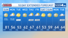
The cherry blossoms are in Stage 4, the peduncle elongation stage! Sunday will be a great day to head to the Tidal Basin to get your glance at the latest stage. There will be a mix of sun and clouds with very warm temperatures. Highs Sunday will reach near 80 degrees.
A cold front is on the way. Sunday night, the front will spark showers and storms as it moves out of Pennsylvania toward the southeast. You could hear rumbles of thunder and pinging of hail as you try to sleep. There could even be severe thunderstorms, so have a reliable way to receive severe storm warnings, even as you sleep.
The storms are expected to march through the DMV overnight and clear shortly after sunrise in time for the bus stop and morning rush. Clouds will clear, and cooler air pours in behind the front. There will be a noticeable difference in temperatures Monday and Tuesday. Temperatures rebound midweek into the 60s.
Download the NBC Washington app on iOS and Android to check the weather radar on the go.
QuickCast
TONIGHT:
Few clouds
Wind: S light
Low: Upper 40s
SUNDAY:
Sun & clouds
Late night showers/storms
Wind: SW 5-10 mph
Gusts @ 20 mph
High: Lower 80s
MONDAY:
AM showers, sunny afternoon
Wind: NNW 10-15 mph
Gusts @ 25 mph
High: Mid 50s
TUESDAY:
Mostly sunny
Wind: SSW 5-10 mph
High: Lower 50s
SUNRISE: 7:08 AM SUNSET: 7:22 PM
AVERAGE HIGH: 58 AVERAGE LOW: 40
Stay with Storm Team4 for the latest forecast. Download the NBC Washington app on iOS and Android to get severe weather alerts on your phone.
About the Author
Discover more from USA NEWS
Subscribe to get the latest posts sent to your email.


