
Multiple waves of strong to severe thunderstorms could develop across the Chicago area Tuesday, with “all weather hazards” at play — including tornadoes — especially Chicago’s northern counties, the NBC 5 Storm Team said.
The forecast comes after a stormy morning, as a line of quick moving scattered storms moving west to east impacted the rush hour commute and led to ground stops at both O’Hare and Midway Airports.
Ahead of the next round, hours of dry time was expected, NBC 5 Storm Team Meteorologist Alicia Roman said. If storms do develop later, some areas will get hit harder than others.
Here’s what to expect.
Where the ‘enhanced’ risk of severe weather is
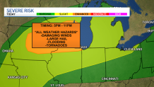
By the late afternoon, parts of the Chicago area will be under an “enhanced” risk of severe weather, which ranks as level three of five. Those areas include far northeastern Illinois, northern Illinois, southeastern Wisconsin and far northern Indiana.
“Most of Cook County, back to the west, including northern sections of LaSalle,” Roman said, of where the enhanced severe weather threat lies. “And all of our northern counties.”
Parts further south under a “slight” risk, which ranks as level two.
Severe weather remains possible later today, threat level 2 and 3 of 5. Confidence in storms forming here locally prior to late evening remains low. However, if they do, they will quickly become severe with all hazards possible! Have multiple ways to get warning info! #ILwx #INwx pic.twitter.com/xXw8Jkmnta
— NWS Chicago (@NWSChicago) April 14, 2026
‘All weather hazards,’ including tornadoes, possible
If storms do develop, they will be “capable of destructive hail, damaging winds and tornadoes, some potentially strong in far northern Illinois,” the National Weather Service warned.
In addition to the tornado risk, downpours, flooding, damaging winds and two-inch hail could be possible, the NWS said, including Milwaukee and parts near the Illinois-Wisconsin border.

At the same time, “some areas may have a dry afternoon and evening.”
Storm timing
Storms weren’t expected to develop until about 5 p.m., Roman said. The greatest threat for fast-moving storms to turn severe would be later in the evening, Roman said, through about 11 p.m. or midnight.
Overnight, another round of showers and storms were expected to develop over the same area, Roman said, though they may lower in intensity. Still, some could contain heavy rain and lightning and lead to flooding, the NWS warned, with hail and “embedded brief tornadoes possible.”
//platform.twitter.com/widgets.js
About the Author
Discover more from USA NEWS
Subscribe to get the latest posts sent to your email.


