
Days like today are where forecasting makes me want to pull my hair out. Spring in New England has to be one of the most challenging places to forecast in the country, you’ll see why in a second. That said, both Tuesday and Wednesday have the risk of showers and storm in the afternoon and evening. I think it’s more likely on Tuesday. If you want the timing on that, please watch the video forecast that’s posted. Not only will it have the most up to date timeline of the storms, but I really want to spend the time on this blog talking temperatures and doing my best to really lay out some possible scenarios.
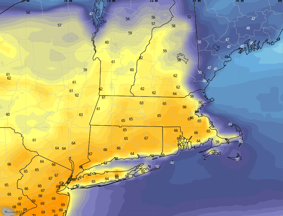
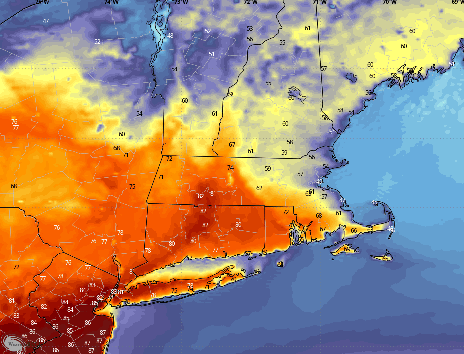
Let’s start with tomorrow (Tuesday). Tuesday is a summer like day inland with temperatures climbing into the upper 70s and close to 80 degrees! It will be cooler on the coastline, generally seeing numbers in the 60s, though Boston may be able to squeak out 70°. It’s a southeast wind which is an onshore wind for everyone except Boston, basically. You get that protection from Norfolk and Plymouth counties to the southeast that will help save you from a full on sea breeze.
Most of the day will have a good amount of sunshine, but clouds will thicken up in the afternoon. In the afternoon we may see a few spotty showers across the area. Later in the evening (like past 6pm) there’s a higher chance of showers or even a few storms moving through. Again, for a detailed timeline on that, please watch the video that’s posted.
Tuesday high temperatures:
Ok, onto Wednesday. Honestly, this is one of the hardest forecasts I remember doing in a long time. We joke sometimes and say could be 80° or could be 40°. Well, this is truly a day where it could be 80° or it could be 40°… all thanks to a backdoor cold front. Or, lack of a backdoor cold front. I’ll start by saying I’m probably buying something between the two scenarios I show you and I’ll explain at the end.
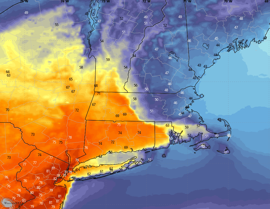
This is the GFS. It’s the American global model. This particular model wants to give us a beautiful summer day with temperatures reaching well into the 80s inland. I’ll step you through the time series below.
Wednesday morning, it’s a mild start, starting in the 60s for just about everyone.
There is a common theme across the models of cooler coast, but maybe it’s more than the coast. By Wednesday afternoon, this model sends numbers well into the 80s with the immediate coast staying in the 60s. Now, I will also say, I don’t buy high temperatures at 87° inland, but if this model would verify, certainly some 82-84s would be possible and likely.
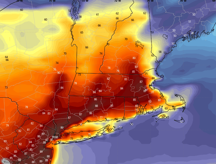
By Wednesday evening, it’s a slow cool down, giving us a nice summer-like night, holding on to numbers in the 60s and 70s through the evening. There’s the risk of a few showers or a thunderstorm Wednesday evening. Again, for timing on that I urge you to watch the video forecast we have posted.
Alright, so that seems pretty straight forward, what’s the problem? Well, let me take you to model 2. This is the American mesoscale model, the NAM. It’s a little bit more hi-res, but that doesn’t automatically make it more accurate. Sometimes this model likes to do some crazy off-the-wall things more than 24 hours out. Sometimes, it sees things that others don’t, because it’s hi-res.
But, like the first model, we see temperatures start off in the 60s Wednesday morning.
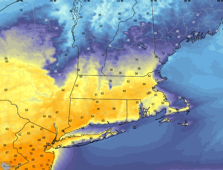
From there, this model immediately kicks in a backdoor cold front by late Wednesday morning. You can almost visualize the colder air moving in from the northeast, dropping temperatures to the 50s and 60s by the midday hours and moving any hopes to a summer like day back into Western Massachusetts. If this model were to verify, the cooler air would kill the storm chance we have on Wednesday evening. I still think we’ll see at least a shower or two, but how robust the showers or storms are is going to depend on this front and how warm/cold the temperatures are.
The cool down continues from there into Wednesday evening, and unlike model 1 giving us a nice, summer-like evening, this one says bundle up it’s going to be quite cold.
Ok, so if you made it this far, kudos, but you’re probably thinking “OK, Josh, this literally tells me nothing. Is it warm or cold?”
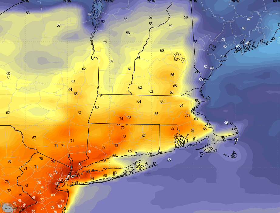
So knowing how volatile this forecast, I’m thinking it ends up being something between the two. There are some other models that support this sort of middle-of-the-road scenario. So right now I think we’ll start off mild in the 60s and as the sun comes out in the morning we QUICKLY see numbers reach the 70s. But that will be by like 11am. From there, the backdoor front kicks in and our numbers fall in the afternoon, through the 60s and eventually 50s.
Thanks for reading! I hope I shed some insight into the forecast challenges and why the 7 day looks drastically different than yesterday for Wednesday, and why it may look different again tomorrow depending on this front. That difference could be even colder, or flip back and the see number go back to the warmer scenario.
Have a nice evening!
About the Author
Discover more from USA NEWS
Subscribe to get the latest posts sent to your email.


